Knoxville Joins Cities Creating Downtown Wayfinding Signage Projects
- Folding Maps
- City Wayfinding
- Campus Wayfinding
As more and more cities focus on tourism to boost their economic coffers, they understand the importance of making it easy for citizens and tourists to navigate their way around. Other cities to embark on wayfinding projects include New York City where a "new systems of wayfinding signs help pedestrians navigate city streets" and Toronto's 360 Wayfinding Strategy in preparation for the 2015 Pan/ParaPanAm Games.
Wayfinding as a Process
Wayfinding first formalized as a way to guide people around by Urban Planner Keven Lynch (1918-1984) in his 1960 book "The Image of the City." It is primarily the process of getting people between two points as efficiently as possible.
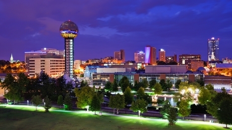
The Knoxville Project
The project funded jointly by the city and the Tennessee Department of Transportation and includes the downtown area plus the World's Fair Park.
According to the article, "the goal of the wayfinding effort is to make it easy for visitors and residents to navigate around downtown Knoxville, as well as, highlighting its attractions and offerings in an appealing and informative manner."
Knoxville World's Fair Park
The Knoxville International Energy Exposition held in October 1982, and the park that was created for the event now is the centerpiece of the city. The theme of the 1982 event was "Energy Turns the World" and opened by President Ronald Reagan.
The park was recently redeveloped to attract tourism and includes a Sunshpere, Court of Flags, and the Tennesse Amphitheatre that hosts concerts, trade shows and more.
Please contact us to learn how we can enhance your campus, event or city wayfinding initiative. We are Pocket Maps, and we get you there in the shortest line!